Previous Archaeological Research in the Area
The majority of Range Creek archaeological sites date to the Fremont era, from about AD 500-1350, when maize farming, hunting and collecting wild plant foods were all important economic activities. From August 2002 to August 2004, researchers, students and volunteers recorded nearly 300 sites in Range Creek. Pithouse villages, rock art panels [Figure 4] , and adobe and sandstone granaries perched high on cliffs are the most common site types. Rock art galleries are found along the entire length of the canyon and include abstract, northern San Rafael, Vernal, and Barrier Canyon style figures (c.f., Cole 1990; Manning 2003; Schaafsma 1980), and possibly a few Basketmaker-like petroglyphs (e.g., Manning 2003). There are likely hundreds more to be discovered because only 10-15 percent of the canyon has been explored.
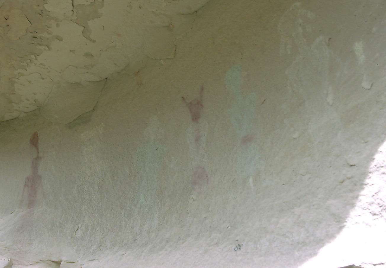
Figure 4. Fremont rock art in the Range Creek area.
Previous archaeological investigations in the Range Creek drainage include the 1931 Claflin-Emerson Expedition of the Peabody Museum (Spangler et al. 2004), a brief excursion in 1934 by Leonard Leh of the University of Colorado, 1954 investigations associated with the Jesse Jennings Utah Statewide Archaeological Survey by James H. Gunnerson of the University of Utah (Gunnerson 1957), and a 1975 rock art reconnaissance by Kenneth Castleton (Castleton 1984). These investigations resulted in the identification of twenty, twelve, eleven and ten sites, respectively, some of which are the same sites described by different investigators. Noel Morss (1954) reported on a set of twelve elaborately decorated male and female ceramic figurines from the Pilling Site in a side canyon of Range Creek. In addition, nine linear cultural resource management surveys passed through the canyon in the late 1970s and early 1980s. Most of these did not report archaeological sites in Range Creek, but one (Christiensen 1983) reported a lithic scatter in a side canyon, and another (Billat and Nielson 1983) reported six sites, at least one of which had been earlier reported by both the Claflin-Emerson Expedition and Leh. All of the Claflin-Emerson sites, the Pilling Site, many of the Gunnerson and Castleton sites, and several of the Leh sites, have been relocated and re-recorded.
Three preliminary radiocarbon dates on maize cobs indicate a Fremont occupation in Range Creek from approximately AD 900 to 1150. These dates fall squarely in the peak of Fremont period (Massimino and Metcalfe 1999), and correspond to the most extensive geographic expansion of Fremont material culture (Madsen and Simms 1998; Talbot and Wilde 1989). Rock art and artifact types from a number of sites suggest that there were several other occupations at Range Creek, including an Archaic, early Formative, and late, post-AD 1200 Formative occupation. The latter is particularly interesting, as artifact and rock art styles suggest it may be associated with an incursion of ideas or peoples from neighboring areas within the Fremont region (c.f. Fremont variants, Aikens 1966; Madsen 1979, 1989; Marwitt 1970), and/or trade or contact with peoples from Anasazi populations to the south. No excavations have yet been conducted, however, and the actual time range represented by the rock art, pithouses and granaries of Range Creek is not yet known. Neither has it been determined which storage facilities are contemporaneous with which residential sites, or even the number of prehistoric occupations and episodes of storage that occurred.
Approximately a dozen relatively large pithouse villages have been documented, in addition to some 50 sites with one or several habitation structures, but none have yet been excavated. These prehistoric communities are typically located on knolls and ridges above the alluvial floodplain and are densely clustered near the confluences of major drainages. Some have standing masonry walls and dark, ashy middens with dense concentrations of ceramics and lithic tools.
One of the most compelling characteristics of Range Creek archaeology is the ubiquity of granaries and caches [Figure 5]. To date, more than 90 of these storage features have been identified and recorded, and many more have yet to be discovered. Structures include small, single-chambered slab-lined caches hidden under ledges and clusters of large, cylinder-shaped masonry and adobe structures cantilevered over cliff faces; many often contain the remains of ancient foods. Several were constructed on top of wooden platforms built of logs jammed into crevices on cliff faces [Figure 6]. Most have substantial timbers in the roof, wall, or base, and are located a substantial distance from the nearest pithouse. Measured volumes vary from less than 30 to more than 2500 liters, or up to approximately 75 bushels of maize per granary chamber. Some still have substantial quantities of maize or wild seeds stored in them, but others were emptied long ago by prehistoric inhabitants of Range Creek and now yield only a few remnant maize cobs as evidence of past use. Many others are filled with sediments and will require excavation to document their contents. The majority are located on cliffs and require technical climbing for sampling and detailed recording.
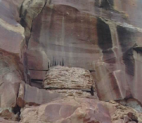
Figure 5. A masonry granary in a cliff-face alcove.
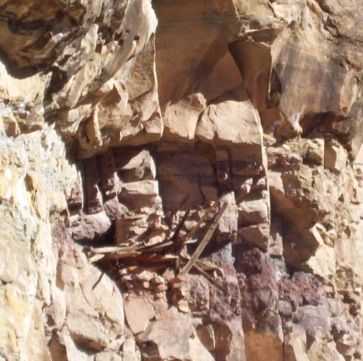
Figure 6. A granary on a cliff face supported by a timber platform.