Pinyon Pine
Tree-Ring d13C
Across the
(continuing research from 1982 to present by
Steven W. Leavitt)
Pinyon-Juniper “(PJ”) woodland occupies vast areas around the semi-arid western states. Tree rings were sampled from pinyon (Pinus edulis, Pinus monophylla) at 14 sites (§ symbol in map below) in 6 western states (photos of representative PJ sites below map) to develop d13C chronologies to investigate atmospheric chemistry, environmental influences and water-use efficiency. Four trees were sampled at each site and four cores were taken from each tree. Pentads from all 16 cores at each site were then pooled to provide samples for each pentad, then d13C was analyzed on cellulose.
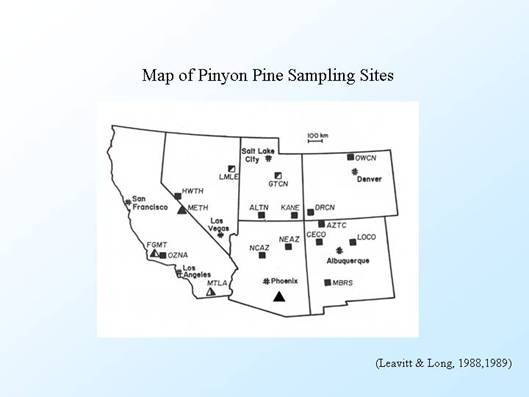
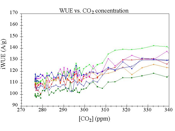
This tree-ring isotope project was particularly noteworthy compared to other contemporary studies because of the exact dendro-dating, and its accounting for intra-tree and inter-tree variability through extended sampling (Leavitt and Long, 1984) and for climate effects using ring widths. The pinyon core collections and isotope analysis were done in the 1980s, and were used to infer atmospheric chemistry (Leavitt and Long, 1988, 1989b), spatial and temporal drought conditions (Leavitt and Long, 1989a), and most recently the results were used by X. Feng and colleagues at Dartmouth to infer intrinsic water-use efficiency (Feng, 1998, 1999).
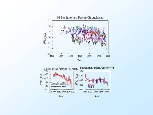
The
chronologies virtually all exhibit a downward d13C
trend post-1800 (raw d13C
chronologies plotted below [top]; mean chronology after correction for climate
effects on Ci/Ca [lower left]; comparison of raw d13C
results from pinyon and juniper in Arizona [lower right]), consistent with the
rising inputs of fossil-fuel 13C-depleted CO2 to the
atmosphere from the beginning of the Industrial Revolution (link to data). The
record from
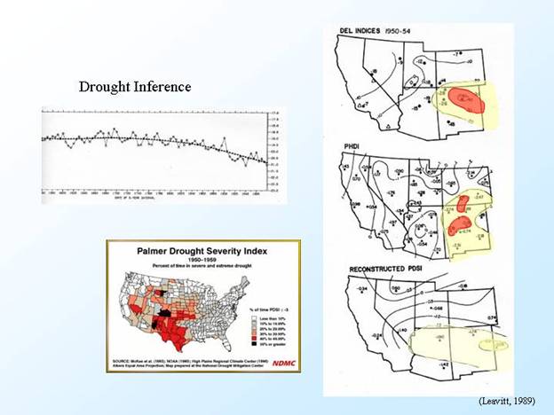
The influence of reduced stomatal
conductance during drought acting to increase 13C/12C
ratios (higher d13C) was
used to identify drought pentads in the records (lower 13C/12C
ratios/higher d13C were used
to infer moister pentads): the greater
the departure of d13C from
the long-term trend, the stronger the inferred drought or moisture excess. This allowed not only development of moisture
records at each site, but the ensemble permitted spatial characterization of
moisture conditions. For example, one of
the strongest historical droughts appears in the 1950-54 pentad,
and the d13C record reveals
a pattern of pronounced reduced moisture centered in
Beginning in 1999, an effort was initiated to resample the complete network of pinyon sites and bring the records up to date with single-year analysis after 1985. The last of the 14 sites was collected in August 2003. Efforts are now ongoing to date and analyze these rings, and interpret high-resolution d13C variation with respect to climate and intrinsic water-use efficiency.
Publications/References:
Feng, X. 1998. Long-term ci/ca
response of trees in western
Feng, X. 1999. Trends in intrinsic water-use efficiency of natural trees for the past
100-200 years: A response to atmospheric CO2 concentration. Geochimica et Cosmochimica Acta 63: 1891-1903.
Leavitt,
S.W., Chase, T.N., Rajagopalan, B., Lee, E.,
Leavitt,
S.W., Chase, T.N., Rajagopalan, B., Lee, E.,
Leavitt,
S.W. and Long, A., 1983. An atmospheric 13C/12C
reconstruction generated through removal of climate effects from tree-ring 13C/12C
measurements. Tellus
35B:92-102.
Leavitt,
S.W. and Long, A., 1984. Sampling strategy for
stable carbon isotope analysis of tree rings in pine. Nature 301:145-147.
Leavitt,
S.W. and Long, A., 1988. Stable carbon isotope
chronologies from trees in the southwestern
Leavitt,
S.W. and Long, A., 1989a. Drought indicated in carbon-13/carbon-12
ratios of southwestern tree rings. Water
Resources Bulletin 25:341-347. (PDF)
Leavitt,
S.W. and Long, A., 1989b. The atmospheric d13C
record as derived from 56 pinyon trees at 14 sites in the southwestern