Reconstructing Large-Scale Climatic Patterns from Tree-Ring Data
Harold C. Fritts 1991.
Arizona Press. 286pp.
and
Associated Program DIFMAP to Display and Analyze the Climatic Reconstructions
65 ring-width chronologies were calibrated with seasonal temperature, precipitation
and sea-level pressure over grids of stations including areas of North America, and,
in the case of pressure, the North Pacific. Canonical regression was used to capture the
important synoptic-scale relationships governing the ring growth. The relationships in
different seasons were calibrated independently allowing for different lags in the
relationships.
The reconstructions were all validated using all existing climatic data prior to the 20th
century. Reconstructions for western North America and the Central Plains appeared
to be valid, but those for the southern Gulf States and the East Coast of the U.S. were
not valid and should not be used in any analysis. The reconstructions of pressure were
valid if one used decade averages or filtered the data to emphasize the low-frequency
changes. The year-to-year variations in sea-level pressure were not reliably reproduced.
The reconstructions of seasonal climate had sizable errors because ring-width
variations included the effects of climate in the other seasons and in prior years. Therefore,
the reconstructions for the seasons were combined into annual estimates as well as
into decade averages. This averaging reduced the error greatly as the effects related to
differences in seasons were self compensating. Thus, it is recommended that the more
than one year's reconstruction be used for analysis.
Program DIFMAP was developed to allow the user to combine reconstructions for more
than one year to test a variety of hypotheses.
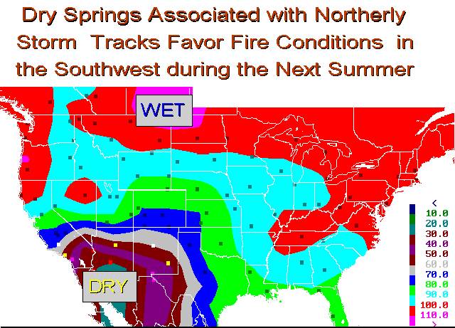
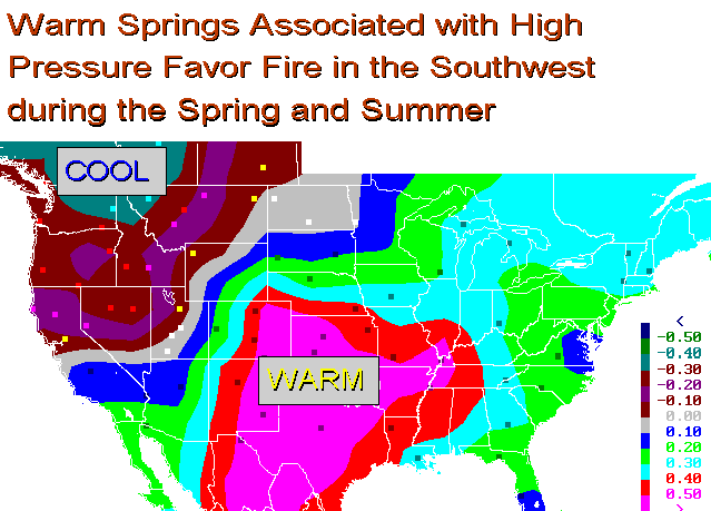
In the following example the reconstructions for a large number of years associated with wide-scale fires in Arizona and New Mexico were
averaged and subtracted from the reconstructions for years of no fires using the program
DIFMAP. The differences between these two groups of reconstructions reveal the anomaly
in climate associated with fire in these two southwestern North American states.
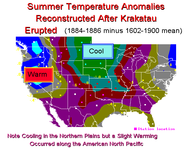
If one looks at the difference between seasonal temperatures following major volcanic eruptions
at mid latitudes and a random sample of all years, the reconstructions show summer cooling in the central regions following eruptions, but there is warming
along the North Pacific coast. (See: Lough and Fritts. 1987. An assessment of the possible
effects of volcanic eruptions on North American climate using tree-ring data, 1602 to 1900
A.D. Climatic Change 10:219-239.)
The following example shows the temperature anomalies after the eruption of Krakatau.
The map was created by averaging the 3 years after the eruption 1884-1886 and subtracting the mean reconstructions for 1602-1900.
At first most climatologists did not take this finding seriously until Robock and Mao (Geophys.
Res. Let. 12:2405-8) tested the tree-ring evidence and found the relationship in the
instrumental record of climate. Robock acknowledged in a letter to Dr. Lough that
Indeed the tree-ring reconstructions had been correct!
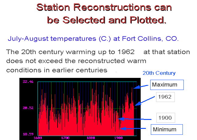
A program called SERIES included in the DIFMAP package allows one to plot and study
the reconstructions for one climatic station for 1602-1963. This has been used to test
hypotheses regarding past climatic variations in a region near the station site. However,
these reconstructions include the climatic information in neighboring stations (as well as
error) so they will not necessarily be identical to the instrumental data for that particular
site.
To Download DIFMAP Files.
Please send me Comments, Questions, or Suggestions.
Return to Hal's Home
Page.
Prepared by Harold C. Fritts hfritts@LTRR.arizona.edu -- Last updated March 17, 2000