Laboratory of Tree-Ring Research

El Malpais, New Mexico Fire Graphs
How to read these fire graphs:
  • Each long horizontal line represents one tree
  • Each short vertical mark represents a crossdated fire scar
  • The composite chronology at bottom shows vertical lines for years with at least two trees recording a fire scar
  • The "Prior to 1900" number is average time interval between composite fires
El Malpais Kipuka fire graph

El Malpais Mesita fire graph

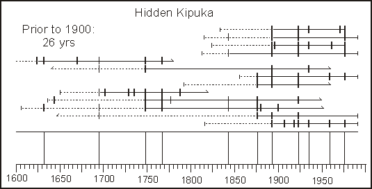
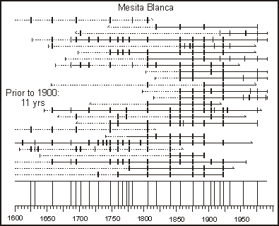
These two fire graphs are quite different from the others of the Southwest:
  • Fire frequency since 1900 is about the same as it was prior to 1900
  • The reason for this is important and is explained in this article
    • Grissino-Meyer, H.D. and T.W. Swetnam. 1997. Multi-century history of wildfire in the ponderosa pine forests of El Malpais National Monument. New Mexico Bureau of Mines & Mineral Resources 156:163-172. This paper describes the past and current fire patterns of sites within the lava flows of El Malpais, the badlands of New Mexico. (1.3-Mb pdf file, password protected)
       

Laboratory of Tree-Ring Research, University of Arizona
Tucson, Arizona 85721 USA
Main Office: (520) 621-1608, Fax: (520) 621-8229
Comments to Paul Sheppard: sheppard @ ltrr.arizona.edu