Dendroarchaeology
Fieldschool 2007 Projects
|
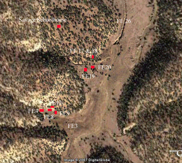
In 2007, the class project involved several days sampling archaeological sites in western New Mexico. The field portion of the course involved sampling two sites (Figure 1), which are located on lands administered by the New Mexico Bureau of Land Management (BLM), Rio Puerco Field Office (the Savage Homestead), and in the Zuni Mountains on lands administered by the Cibola National Forest Mt. Taylor Ranger District (Quaking Aspen Peeled Tree Site). |
Figure 1. Map of the 2007 project locations. |
|
Figure 2. Mt. Taylor looking north from El Malpais. |
Dominated by Mt. Taylor (Figure 2), also known as Dootl’izhiidziil--the Navajo sacred mountain of the South—the area is nestled between the Colorado Plateau on the north, Rio Grande Valley on the east, and Mogollon Highlands on the south at an elevation of 6500-7500’ asl. The most significant geologic features of the area are the great lava flows emanating from Mt. Taylor (Figure 3), which are bounded on the east by sandstone cliffs of Cebollita Mesa (Figure 4).
|
|
Although abundant archaeological research has been conducted in the area of the past 100 years, only a recent CRM-related survey, and an MA thesis directly concern this project. In the BLM area, Roney did a tremendous job documenting the many features on the Savage Homestead in 1989; his photographs have proved to be an invaluable resource for both research and preservation efforts. Gallassini’s MA thesis at Eastern New Mexico University in 2007 documents many aspects of cambium peeled trees in the Zuni area.
|
|
The El Malpais area has been the subject of significant research in the past—both dendrochronological and archaeological. Dendrochronology received a major boost by the discovery of long-lived Douglas-fir trees on the El Malpais lava flows; the dendroclimatic information gleaned from these trees has played an important role in recent reconstructions of long-term trends in southwestern precipitation patterns (Grissino-Mayer 1996). |
Figure 3. The El Malpais lava flows looking southwest |
The nature of the project and project participants necessitated a dual set of goals. First, student training was of paramount importance. The primary objective of the Geosciences 497J/597J course is to train students (undergraduate and graduate) and professionals in the collection, analysis, and interpretation of dendroarchaeological samples. This goal was clearly met: the course involved lectures on dendrochronological theoretical and methodological principles, and the field portion provided “real life” technical, logistical, and methodological problems for the students to solve. It also provided the opportunity of the students to work as a team in a field setting as they received training and practice in standard dendroarchaeological sampling techniques. Finally, the laboratory analysis portion of the course taught the students the basics of wood species identification and crossdating, and allowed them to develop their own interpretations of the data collected in the field.
In terms of the specific sites investigated, our goals were strictly dendroarchaeological. We wanted to glean as much chronological, behavioral, and environmental information from the sites and samples as time allowed. We conducted no additional archaeological documentation or analysis beyond that necessary to interpret the contexts of the tree-ring samples. In the chronological realm, we wanted to learn when the sites were initially founded, how long they were occupied, and when they were abandoned. In terms of behavior, we were interested in the site occupants’ view of wood as a resource—which species did they exploit for which structures and architectural elements? What tools and methods did they use to procure and modify wood to meet their needs? Did they preplan construction and stockpile timbers? Did they repair and/or remodel structures? Dendroarchaeological samples contain two types of environmental information: climatic and distributional. A dendroclimatic reconstruction was far beyond the scope of this project, although Grissino-Meyer’s (1996) El Malpais reconstruction provides relevant data. The tree species exploited by the site occupants are the results of both cultural choices and environmental availability, and we noted—but not in any formal systematic fashion—the locally available species near the sites. Finally, the excellent documentation of the homestead by Roney allowed us to conduct “casual repeat photography” research at the Savage Homestead; Stacy Gallassini’s excellent and on-going research on the peeled trees provides us with abundant data as well. |
|
The Savage Homestead |
Cambium Peeled Trees |
Repeat
Photography |
Acknowledgements: This project was a collaborative effort of the Laboratory of Tree-Ring Research, Bureau of Land Management Albuquerque District, the Cibola National Forest Mt. Taylor Ranger District, and Manzanares Research, Inc. BLM archaeologists Dr. Signa Larralde and Gretchen Obenauf and Rio Puerco Field Office Director Tom Gow deserve credit for bringing the homestead sites to our attention and our thanks for facilitating the project. USFS archaeologists Cynthia Benedict, Linda Popelish, and especially Stacy Gallassini helped tremendously with the peeled trees. Dr. Tom Swetnam, Director of the LTRR, has supported the Dendroarchaeology course in many ways, for which we are extremely grateful. As always, Jeff Dean’s aid and advice have proved invaluable. Jim Parks, Rex Adams, and Chris Baisan of the LTRR helped immeasurably throughout the class. The Savage Homestead research was partially funded by a grant from the New Mexico SHPO ably administered by Shalie Gasper. Finally, the students and participants, Mark Bertogliati, K. Reneé Barlow, Paul Creasman, Adam Patterson, and Aaron Wright did all the work and deserve the credit and my thanks. |
Ron
Related Links Return to Dendrochronology Fieldschool Webpage Return to LTRR homepage